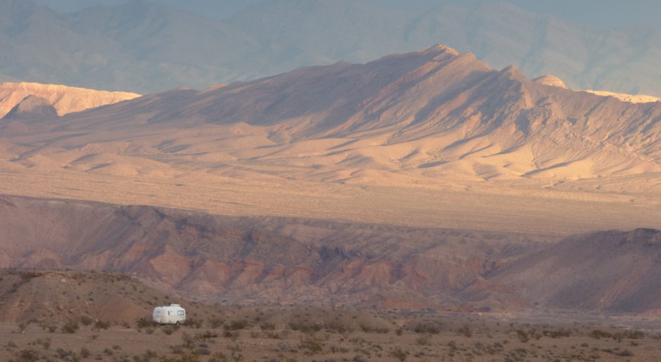
The crew and I are at Tuttle Creek Campground.
Before leaving the Lone Pine area, I want to take advantage of the dump station ($5). As I’m pulling away, a guy comes walking down the campground road. His eyes are fixed on me and he’s smiling.
“Hello, Sue,” he says, approaching the window of the PTV.
“Well, hello!” I respond. “You must be a reader of my blog.”
“Yeah, I’m Kent.”
“Are you the Kent who left a card in my door . . . way back in 2011 in New Mexico?”
“That’s me.”
“And you also comment sometimes . . . . ”
We talk and laugh for several minutes.
Kent and his wife Carmen are full-timers now. He mentions that Mick, my cyber-friend and the technical advisor for this blog, and he were in touch regarding a Wilson antenna like mine. Kent went ahead and bought one, and he and Carmen are happy with it. Theirs is mounted on a telescoping flag pole.
We say goodbye and Kent adds, “We’ll probably meet again sometime.” I wouldn’t be surprised that we do!
My next stop is Casey’s Auto.
Coincidentally another Casita is parked next to the garage.
 Once again the connector on the cord that goes from the PTV to the BLT, transferring power from the batteries inside the PTV to the house battery, has been damaged. It came loose while we were on the road and bounced on the ground.
Yesterday, when here for the PTV’s oil change, I showed the mechanic the connector and asked him to put it on the cord for me when I come through town with my trailer. So that’s why we’re here.
 It only takes a couple minutes and we’re on our way!
Well, a quick stop to top off the gas tank and then we’re on our way, heading south on Route 395. Since I have a short journey planned, I’m relaxed and feel free to stop for photos.
 I pull over at the little town of Olancha and grab a shot of Olancha Peak (12,123 ft) while Bridget howls in protest.
 I dash across the road and snap a photo of some sheep. Sheep are not like horses and mules which make for interesting photo subjects with their varied colors, graceful forms, and interesting personalities. Sheep are . . . well, sheep. They stand. They look. They graze in almost identical poses wearing similar coats.
 Back on the road, it’s an easy, enjoyable ride on this clear, sunny, autumn day . . . the last day of October.
A slice of blue appears in the distance, to the east of the highway.
That’s North Haiwee Reservoir (page 87 in the Benchmark California atlas). Somewhere around here there’s a road going over that way. Last year I was timid about exploring down that unknown dirt lane with the BLT in tow, but this year I’m giving it a try.
South Haiwee Reservoir appears and soon afterward I see a break in the divided highway. I make a left turn across the highway onto a dirt road, immediately rumbling over a cattle guard. A brown BLM post alongside the road confirms what I saw on the map.
This is public land.
The road takes us toward the mountains. A sliver of blue beckons (left side of photo below).
 The more I see of the reservoir, the more my anticipation grows.
 Oh, this will be a fantastic boondock! No one is here. It looks like you can walk down to the water. I love this! And there are trees!
 Up ahead is a fork in the road.
Two white signs are posted there.
Uh-oh. I strain to read them as we approach. “OH DARN! . . . Darn, darn DARN!”
One sign says, NO PUBLIC ACCESS.
The other sign says, TAMPERING WITH A TRANSMISSION LINE IS A FELONY AND IF YOU DO IT, YOU’LL BE CAUGHT BECAUSE WE PATROL THIS AREA REAL GOOD, AND YOU CAN BET YOUR BOTTOM DOLLAR THAT WE’LL SLAP YOU WITH A HEFTY FINE, LIKE A THOUSAND DOLLARS, SO DON’T EVEN THINK ABOUT IT, BUSTER. Yours truly, Los Angeles Gas and Light. Something like that.
I turn our sorry selves around and we bumpety-bump on out of there. Gee, how disappointing.
Last year we camped at Fossil Falls.
You may remember my post about all the lava. Lots of lava. Big, black, ugly mounds of lava. Enough lava to satisfy any urge to see lava for the rest of my life.
I pull off Route 395 onto Cinder Road, and drive right on by Fossil Falls Campground.
Cinder Road takes us to a desert basin.
 We cross a small, dry lake bed and pass Red Hill (3,952 ft) with lava piles at its base. Long spur roads head off to the north and to the south. Looking across the treeless desert, I can see that the north road eventually turns to the east toward more dadburn transmission lines.
I turn to the south.
 A few Joshua Trees grow on the vast plain of dry sand and tan scrub. After bouncing along on the dirt road for a mile or two, I park the PTV at a turn-around area by a crossroads. Bridget and Spike are restless. They know bumpy roads may mean we’re close to our new home.
“C’mon, you two. Let’s walk up there and see what the road is like.”
Spike leads the way.
 Turns out the road leads to more of the same. As we walk back, I look at the PTV and the BLT in a new light.
 I don’t normally camp with the PTV and BLT totally exposed. However, here I can turn 360 degrees and not see any sign of another human being. Are we exposed if there’s no one around to look?
 I think we’ll make camp right in the middle of this huge, empty basin!
 I find a patch of hard ground that’s clear of any shrubs. I don’t even have to level. It’s perfect.
 I want seclusion and that’s what I’ve got!
 Not to mention, five steady bars for internet!
rvsue
THANKS FOR SHOPPING AMAZON HERE!
Here are a few samples of recent purchases by readers of this blog:
Cuisinart 2-Speed 200-watt Immersion Hand Blender with Attachments
Duragold 14k Yellow Gold Half-Round Hoop Earrings
Perplexus Maze Game by PlaSmart, Inc.
Compact Laser Printer with Wireless Networking and Duplex
Rubbermaid FastTrack 48-by-16-Inch Wire Shelf
Midwest Black E-Coat Exercise Pen, 24 Inches by 30 Inches


“REAR VIEW MIRROR”
November 30, 2011, the solar panel with tilting mechanism is attached to the roof of the Perfect Tow Vehicle. When the crew and I return to the Best Little Trailer at our campsite at Percha Dam State Park, NM, we find a card left by Kent.

