We find a dreamy, desert camp!
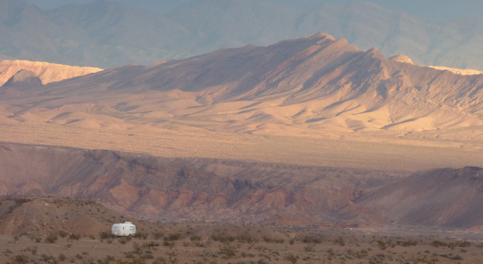
As I write this post on Thursday, November 19, here is where we are. The photo was taken last night at sunset. Although the back-lighting caused the photo to be dim, I like it so I’m posting it. See the munchkins?
 Okay . . . Let’s back up in time for you to travel the route that brings us here.
Tuesday, November 17
After a day of non-stop wind, the crew and I hit the road very early. A return of the wind is predicted for today. It’s calm this morning. Maybe we can find our next camp before the wind returns . . .
We leave Turtle Mountains Wilderness Camp and head south on Route 95.
You may remember from the previous post that we’re on the west side of the Colorado River. At the southern end of Chemehuevi Valley we come to Vidal Junction and turn east on Route 62 until we reach Parker, across the river and across the California border into Arizona.
Parker is a magnet for RVers.
 I’m not surprised to find the place is hoppin’ after a day of strong winds. I stop for propane and then head over to Wal-Mart. Wait a minute. . . Safeway is across the street. That might be a nice change, a better shopping experience perhaps?
Well, the atmosphere is more mellow than Wal-Mart’s. However, it isn’t long before I realize I’m not putting items in my cart that I planned to purchase because of the prices. For instance, I pick up a bottle of blueberry smoothie — $2.48 at Safeway and I know it’s $1.94 at Wal-Mart. Prices are consistently higher.
After the ambiance is long forgotten, the money is still gone. I’m outta’ here!
I drive across the street to Wal-Mart and load up!
By the time I come out of the store, load the groceries into the Best Little Trailer, and walk the crew, the wind arrives. We need to find our camp soon. Where shall we go?
I want to go south and I want to stay away from Quartzsite.
That means we go back across the river to California. A brief study of the California Benchmark atlas and I have a general idea how we will travel on our search for a good, desert camp away from the crowd.
We’re buffeted by a crosswind from the north while on Route 62 again, going west this time. At Vidal Junction, we turn south on 95. This is not a scenic drive. Lots of dull brown rock and dirt, dusty desert, only one glimpse of the river . . . .
I don’t care! I need to find a camp! Fortunately we’re helped along by the tailwind.
Through the Colorado River Indian Reservation . . .
We arrive at Blythe. We go west at 4th Avenue. At the stop sign I turn north onto Lovekin Boulevard which becomes Midland Road to the northwest. The Big Maria Mountains are on our right. I’m too weary to scout out a boondock, but I will if there isn’t a better choice.
I take a look at the Midland Long Term Visitor Area.
Not that I want to stay in one place “long term.” If this looks good, we’ll stay “short term.” (14 days) If not, I’ll take a late lunch break with Bridget and Reggie, gather up a second wind of my own, and keep looking.
To be continued . . . . with more photos next time!
rvsue
THANK YOU FOR SHOPPING AMAZON FROM HERE!
I appreciate you doing your holiday shopping from my blog. I will keep ads current to notify you of sales as they occur throughout the season.
 CLICK LINK TO SHOP AMAZON NOW!

